The Patriot Files Forums The Patriot Files Forums |
| Home | Forums | Gallery | Register | Video Directory | FAQ | Members List | Calendar | Games | Today's Posts | Search | Chat Room |
|
||||
Before enlarging, click photo to ensure maximum resolution.
|
| |||||||||||||||||||||||||||||||||||||||


 Photo Details
|
|
|
David Administrator Registered: August 2001 Posts: 46,799  |
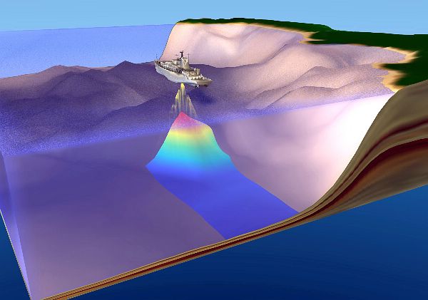
An illustration depicting the underwater mapping capability of USNS Bowditch (T-AGS 62) and other ships of her class. T-AGS 60 Class Oceanographic Survey ships conduct sampling and data collection of surface, midwater and ocean floor parameters; launch and recovery of hydrographic survey launches (HSLs); the launching , recovering and towing of scientific packages (both tethered and autonomous), including the handling, monitoring and servicing of remotely operated vehicles (ROVs); shipboard oceanogaphic data processing and sample analysis; and precise navigation, trackline maneufvering and station keeping to support deep-ocean and coastal surveys. There are 5 ships in this class. U.S. Navy Graphic Illustration
|
| · Date: Fri December 20, 2002 · Views: 1204 · Filesize: 31.5kb · Dimensions: 600 x 421 · |
|
| Additional Info | |
| Keywords: An illustration depicting | |


     |